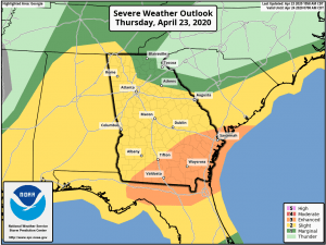
South Georgia: A line of severe thunderstorms will continue to push through South Georgia this afternoon. There will be several severe thunderstorm warnings and tornado warnings on it as it moves from west to east this afternoon. There will likely be multiple waves of strong line segments that move through South Georgia this afternoon and evening, producing damaging winds and a few tornadoes. The severe weather threat will end from west to east this evening and overnight.
North and Central Georgia: There are still expected to be some scattered showers and thunderstorms throughout the afternoon and evening, but the severe weather threat has diminished somewhat due to stabilization of the atmosphere from this morning’s activity. However, strong to severe storms are still possible this afternoon and evening. The storms should come to an end by late this evening.
This Weekend and Next Week: All storms should move out of Georgia by sunrise tomorrow, with great weather expected for the rest of Friday. Another system will bring a chance for showers and storms across North Georgia on Saturday, but the threat for any severe weather is low. Sunday, Monday, and Tuesday will be dry, sunny, and mild. A cold front will move through Georgia on Wednesday, bringing another chance for showers and thunderstorms statewide. The risk of severe weather with that system appears low right now as well. Thursday and Friday next week look dry and sunny.